Understanding Western New York
I have spent the last six months trying to understand and read the landscape around me. I have seen the industrial region on the flat landscape of Tonawanda, north of Buffalo. I have seen the orchards along the flat landscape along both Lake Ontario and Lake Erie, with a ridge rising just inland from them. I have sat on Chestnut Ridge, south of Buffalo, at sundown with the incredible views of the city. I have, of course, visited Niagara Fall and I have seen the Lockport canal locks which are part of the Erie Canal system. And finally, I have traversed inland to visit the Letchworth Gorge on the Genesee River.
I have had to work to put together all of these individual places into a coherent mental map of the Western New York region and its history. A typical approach of a geographer is to first understand the physical landscape on which the human history was build. In the case of Western New York, the landscape if shaped by a series of escarpments or steep faces of higher plateaus. These escarpments all run generally east-west.
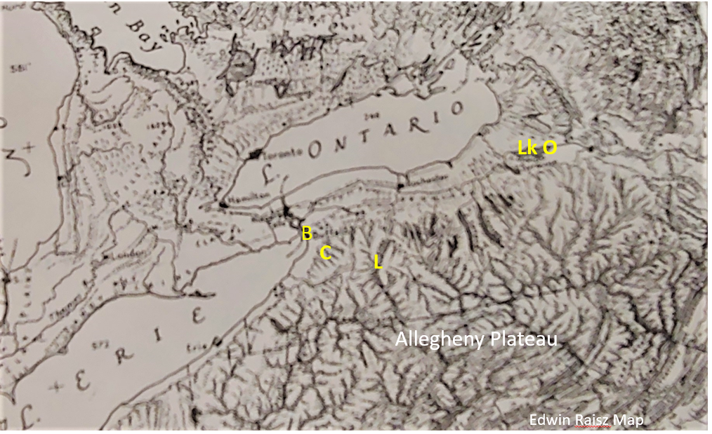
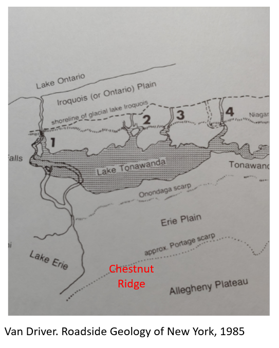
My mental map has developed into a mental map of belts of east/west landforms that lay parallel to the Lake Ontario shoreline. Starting south of Buffalo, you encounter the southern-most of these landform belts, the Appalachian Plateau. In states to the south it is called the Allegany Plateau or the Cumberland Plateau. The Appalachian Plateau is essentially the western edge of the Appalachian Mountains, made of sedimentary rocks that are tilted slightly southward. The plateau is stream-dissected meaning that the landscape has been eroded down by the work of streams, cutting steep valleys into the rocks. The boundary between the Appalachian Plateau and the glacial deposits to the north of it, is the southern-most escarpment in the Western New York region—the Portage Escarpment. It is about 1000 feet in height. In the last ice age, the ice sheet could not rise to a height to cover the escarpment so it ended up scouring downward, creating the Finger Lakes to the north of the scarp. This left the land to the north of the escarpment as primarily glacial till on top of bedrock.
Chestnut Ridge is a park on the very edge of the Appalachian Plateau just south of Buffalo. People gather there to hike, to picnic, to go sledding, and to just sit and enjoy the sunset and views from the highest point around. Below you lays the flat Erie Plain, Lake Erie, and the City of Buffalo.
The Genesee River also flows north from the Appalachian Plateau onto the glacial deposits to the north. I visited the Letchworth Gorge and its waterfall, on the Genesee River, on a beautiful fall day, reflecting on my ancestors who recorded their trip down the Genesee River as captives of Native Americans. In reading about the formation of the gorge, it is clear that it came about through the interaction of stream erosion and glacial meltwater lakes at different levels. At Letchworth you can see the power of erosion and also the plateau on which the water has exerted its force.
As you descend the Portage Escarpment, leaving the Appalachian Plateau and head north, you cross the Erie Plain, an area of glacial till deposits. This flat plain is another east/west belt that extends as far as the northern side of Buffalo, where you find the next East/West escarpment, the Onondaga Escarpment, at about the latitude of route of Highway 90. This escarpment is not as evident as the Portage Scarp. Primarily I’ve seen it as outcrops/road cuts showing limestones and dolomites along highways.
Once north of the outcrops of the Onondaga Escarpment, the land is again flat and is dominated by the industrial landscape of Tonawanda, which sits on the site of the former glacial Lake Tonawanda.
The final two east/west landforms are the Niagara Escarpment, again running east/west and cross the Niagara River at Niagara Falls, and then finally the flat Lake Ontario Plain, the remnant of the expanded glacial Lake Iroquois. The plain is an area of orchards, sitting between the lake and the Niagara Escarpment providing a unique micro-climate. Across the border these same features create the fruit belt and vineyard region of Ontario.
How has this series of landform belts shaped the cultural and economic landscape of Western New York—Appalachian Plateau, Portage Scarp, Erie Plain, Onondaga Scarp, Tonawanda Glacial Lake plain, Niagara Scarp, and Lake Ontario Plain? European settlement in the region originated in the need for more arable land as it became short in New England. Veterans of the Revolutionary war were awarded tracts of land in Western New York. The best of these lands were the flat northern areas underlain by glacial materials. Natural power sites tied to the escarpments, fertile agricultural lowlands, and access to the Eastern markets via the Mohawk and Hudson River Valleys, all contributed to the agricultural and manufacturing development of western New York. The Erie Canal was built to enhance that locational advantage. It was finished in 1825 just north of the Niagara Escarpment, built along the Lake Ontario plain, extending from Oneida Lake where the Mohawk River ended, all the way to Lake Erie. Lockport was a major site where five locks were constructed to bring boats down to the level of Lake Erie.
Buffalo became a market center where products of the Great Lakes region—grain, lumber, and iron ore—were received, milled, processed, and sent eastward.
I have spent the last six months trying to understand and read the landscape around me. I have seen the industrial region on the flat landscape of Tonawanda, north of Buffalo. I have seen the orchards along the flat landscape along both Lake Ontario and Lake Erie, with a ridge rising just inland from them. I have sat on Chestnut Ridge, south of Buffalo, at sundown with the incredible views of the city. I have, of course, visited Niagara Fall and I have seen the Lockport canal locks which are part of the Erie Canal system. I have traversed inland to visit the Letchworth Gorge on the Genesee River. I now see them all as pieces of the whole that makes up the cultural and economic landscape on which I navigate my understanding of my place.


